Cooler, rainy weather over the past few days has helped firefighters in their battle to tame the Timmins 2 fire burning four kilometres from Gogama.
The small community two hours north of Greater Sudbury up Highway 144 was estimated on Sunday to be about 6,000 hectares in size, but with less smoke obscuring visibility on Monday, that original estimate has been revised.
Still, the fire is around 5,000 hectares in size, burning on the west side of Highway 144. The community remains under a voluntary evacuation order. The Ministry of Natural Resources and Forestry has also recommended a two-hour evacuation order for residents of Gogama and surrounding areas.
As a health precaution, Mattagami First Nation evacuation 30 young children and elderly people on Saturday night when smoke was at its thickest. Those people were able to return home on Sunday.
Despite the favourable weather on Monday, Timmins 2 is still listed as out of control. Firefighters have managed to hold the fire at four kilometres west of Gogama, burning on the west side of Highway 144 and running parallel to the roadway.
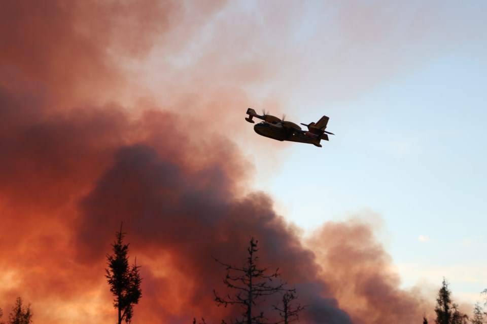
With the blaze exhibiting extreme fire behaviour on the weekend, firefighters with the Ministry of Natural Resources and Forestry attacked it aggressively, including using aerial fire suppression.
“Fire behaviour and the spread potential depend greatly on the weather pattern,” MNRF said in its latest report on the fire. “Throughout the weekend the combination of warm temperatures, moderate winds and low relative humidity permitted Timmins 2 to spread and increase in size.
“The low pressure system that moved into the area over night (June 9 into June 10) brought much need precipitation, cloud cover and cooler temperatures. This change in weather pattern will help FireRangers on the ground establish hoselines.”
MNRF expects today to be a “quiet” fire day, but there could be more smoke compared to yesterday as the rain clears.
The ministry has committed an incident management team, 20 FireRanger crews, CL-415 Waterbombers and Twin Otters when needed, seven helicopters and heavy equipment to build fuel breaks around the fire. A small basecamp has been established in Gogama.
Travel restrictions
Highway 144 was opened and closed to traffic several times over the past few days, but remains open at this time. Travellers are advised to monitor the changing conditions using Ontario511 or @OPPCommunicationsNER on Twitter, and Ontario Provincial Police-Northeast Region on Facebook.
As part of | the Emergency Area Order signed June 10, the ministry has issued an Implementation Order prohibiting access and travel in portions of Timmins District where there are public safety hazards as a result of fire activity from Timmins #002.
All travel and use of Jack Road from the intersection of Jack Road and Highway 144, west to the Ontario Power Generation Mesomekenda Lake Dam at Mesomekenda Lake is prohibited. All travel and use of Gogama Unit Road from the intersection of Highway 144 and the Gogama Unit Road, north to the north end of Carter Township is prohibited, as well.
All use and occupation of Crown Land or within 500 metres of the described closed roads within this area is prohibited.
If a member of the public believes that access within the restricted travel area is necessary for non-recreational purposes, please call 705-235-1334 to request a travel authorization permit.
Visit Ontario.ca/forestfire to view the current access restrictions and fire activity as this site is being updated regularly.
Across the northeast
As of the early evening of June 10, there are four active wildland fires in the region.
Chapleau 4 is located north of Hwy 101 between Timmins and Chapleau. It is being held at 16.5 hectares. Sudbury 2 is under control at 0.2 of a hectare, on the southwest side of Windy Lake. Sudbury 6 is under control at 0.5 of a hectare north of the French River.
At the time of this update, the fire hazard is mostly low in the Northeast region; with the exception of the southeastern most part of the region which is showing a moderate to high hazard.