“Did it, made it!” Beyond, the back roads we went! Remember three things - stay warm, stay dry, and keep a positive attitude.
To the most northern point, one can go to Ontario. The mini expedition was the final push to the extreme corner of the province. The centre of the province and the other three cardinal extremities were surprisingly attained earlier this year, starting in late March. Brian Emblin from Timmins has been a willing and supportive companion all along the way(s).
This story was compiled from mini diary entries, snippets of handwritten notes, scribbled, each night, into a green bound journal by the light of a Coleman lamp that sounded like the continuous heavy breathing of Darth Vader. I entitle this: Mindful Thoughts on the Tundra – this Unique Place.
Expedition
The north boundary with Nunavut and Manitoba was to be the crème de la crème of logistics the planning leads to a mini expedition but we are not Shackleton, (leadership odyssey), Peary (North Pole) or Scott (he died in trying to reach the South Pole). We are just ordinary beings, with some interesting geographical musings, of the land and its people.
To get to the most northern point we must first find Fort Severn.
Sioux Lookout is an unsecured (no security check-in) hub of transportation for northern remote fly-in First Nations and our destination to begin the air leg of our journey. We were on a small regional carrier, Wasaya Air, and the turboprops gave us a midway-ride feel upon takeoff and landing. En route, we landed in Wapekeka and Kitchenuhmaykoosib Inninuwug (Big Trout Lake).
The Dash 8 we switched to during our flight to Fort Severn is 33 years old and has the original ashtrays on the armrests.
On the way back from Fort Severn to Sioux Lookout, we took a smaller Beech 1900 twin-engine turboprop with 14 seats. One seat was on the aisle and some seats were removed for the bountiful amount of community cargo. The pilots looked almost too young and they pumped their own aviation fuel, checked tickets and loaded/unloaded cargo, all part of their apprenticeship. When we landed, we could hear the sound of a gravel runway and the only concrete tarmac was a small square that is only as big as the plane.
Our destination was Washaho First Nation (wash-a-hoe), or Fort Severn, the most northern settlement in the province and it is where we finally meet George Kakekaspan, who had agreed to guide our expedition after an infinite number of planning texts and emails. We were fortunate to contact George through Brian’s school friend Bruce Achneepinsskum, Chief of Marten Falls First Nation.
George Kakekaspan (Kah-kee-kas-span) has “traditional land knowledge.” He is 6’3”, wears size 13 winter boots and has basketball hands. He is a gentle giant.
Having lived in Fort Severn for most of his life, George knows the area well. He has five children and his wife, Dora, is a teacher at the community school. He is a Canadian Ranger and once served as Chief of the First Nation for two terms.
You have to listen carefully to George because he is a soft-spoken man. His few words always have direction and cultural wisdom. He has that wry and engaging sense of self and humour.
For instance, when I asked George how he knows why the polar bears are on the other side of the sand dune he said, “I am an Indian!” And then he explains, “Wouldn’t you want to be out of this wind?”
He is always ready with his gun, slung over his shoulder and for good reason.
We left right away and spent the first night in a low-walled, canvas tent not so far from Fort Severn, 11’ (3.3 m) above sea level. We were already on the lowland flats.
George has a 'smoking tent' in the shape of a teepee for the goose hunt. It was here we readied ourselves for what lies ahead. The flapping of the canvas kept me awake in anticipation.
We took a dry run with the ATVs and it was good practice.
They were Honda Rubicon 520 models with a standard five-up shift. The saltwater is too hard on automatic transmissions and the low gears are so important for traversing the round rocky rills and mud flats. The transmission shifting sound through the day was a continuous one.
Have a listen to the first thirty seconds of How to manually shift a Honda Rancher and get a feel for what was in our heads most of the day.
We got on and off our ATVs many times during each day to check ground conditions and slopes. Dressed in winter layers with neck warmers and double toques, it's not an easy task. We were always cognizant that there is no immediate help. We were always thinking – never go in the water.
As is normal for the area at this time of year, it was light just after 8 a.m. and dark by 7 p.m. so we made the most of the daylight.
The Northern Lights made the nights spectacular. When you see these, at any time, you are in awe, almost in that fairy tale state of mind; “WOW” can never be expelled enough.
Hudson Bay – ocean
It is a region and habitat that few Canadians know much about.
The Hudson Bay Lowland is a wetland area of Canada that covers about 320,000 square km (123,553 square miles) surrounded by the Canadian Shield. It falls largely in Ontario and Manitoba.
As part of a sedimentary basin, the Paleozoic limestone of the area was covered by glaciers during the Pleistocene Epoch (2.58 million to 11.700 years ago).
The land is continuing to rebound from the weight of the ice and it rises about six millimetres a year. As the Laurentide Ice Sheet retreated, it was replaced by water, an infinite number of small, ice-lobed ponds, which left a layer of marine sediments. Walking the land, you can see diminutive sea shells everywhere. It has a corrugated appearance of beach berms and wavy linear dunes.
Moving closer to the bay we moved beyond the tree line. The coastal portion of the lowland consists of level plains of tundra, bog-like muskeg and peat, dotted with these shallow ponds. Our journey took us through 155 km of this diversity, always a circuitous route, and it seemed like the moon away. With climate change, we now know these are carbon sinks critical for carbon sequestration.
We were in hip waders all day. Note to me – should have bought the oversized with thermal inserts.
It was important for us to “stay ahead of the tides,” George said. Understanding tide heights and when high or low tides occur can help you decide the best time to cross the countless tidal estuaries and rills that are created in the mud flats.
The rivers are full of round rocks and holes which swamped the ATVs. The rills are deep ruts so we must decelerate there or risk being thrown off the machine. George was continuously looking for places to cross; meandering and zigzagging.
The only straight-line runs are along the endless Daytona Beach stretches of Hudson Bay. It's kilometres of hard-packed sand, like a highway with no name and no traffic except for polar bear tracks.
The food we ate along the way was dried, mostly rice and pasta in foil-like packages. We boiled water, poured it into the package, stirred and let it sit until rehydrated. It was accompanied by tea or instant coffee sticks. We had porridge packs in the morning, with the addition of dried fruit - always with prunes. Power bars and GORP (Good Old Raisins and Peanuts) were our staples during the day. All gear was stowed within heavy dry bags and we needed to take along many sturdy plastic Jerrycans, strapped to the back of the bikes. George always had his 0.308 rifle in the sling around his torso.
We also had to have a chainsaw. Especially beyond the tree line with only sporadic driftwood available we needed it to beach-comb for firewood. There are shared community caribou hunting huts along the way. They’re mostly 12’X16’ cabins with a small barrel-type of stove, a couple of bunks and a shelf that acts as a table.
We appreciated the intense heat from those stoves and the parachute cord clotheslines we festooned with the layers of clothing we shed was a lifesaver. We were tundra-tired by the final hut and the furthest point remained more than 50 kilometres away. We were thankful to have Garmin InReach satellite communication.
Survey and the northern point
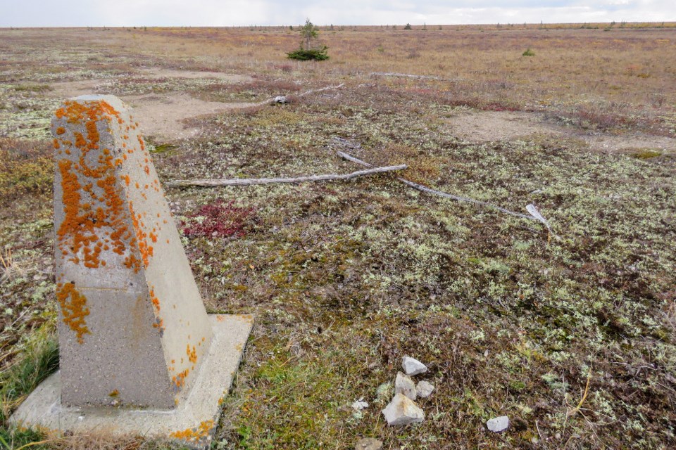
We are first looking for the concrete monument Number 457-A, it is the most northern surveyed monument denoting the border between Manitoba and Ontario. It is identified and described in the Ontario-Manitoba Boundary Act.
“The boundary surveyed and marked on the ground by commissioners appointed in 1897, 1921, 1929 and 1931 to delimit the boundary between the Provinces of Ontario and Manitoba,” says the act.
As there are no trees or only bonsai ones, the four-foot (1.21 m) tapered pin in the distance that marks the northernmost point in the province is easy to spot. The GPS coordinates lead us to the seldom-visited marker surrounded by caribou tracks, George is glad of the evidence.
The cut-off remains of a former miss-surveyed monument are also evident nearby. This one has a 1950 bronzed medallion on the top, with the Ontario emblem, the last time it was surveyed.
It looked like not many have been to the marker and the relative barrenness of the location made me notice our provincial emblem like never before. Without colour you see what would be the (red) cross of St. George, symbolic of England, appearing in the upper third of the shield. The lower portion of the shield features three (golden) maple leaves, emblematic of Canada, on a (green) background. The shield is supported by a moose and a Canadian deer while a (black) bear appears on the crest above the shield.
We were lost in thought on the tundra with a sense of pride and the feeling of accomplishing “why not.” Only two other people have experienced this vast and magnificent land from the centre to the other three Cardinal direction extremities with more than 1,600 km between each.
To mark our visit, we left a metal cache cairn with some mementoes and a story of the quest for the next unexpected visitor to this remote spot. Then, as quickly as the feeling of accomplishment arose, the warm feeling of having reached the northernmost marker quickly waned.
We stepped across the imaginary line of the border to have lunch in Manitoba on the NW side of the monument and then depart. While in the area, George spotted and shot 24 ptarmigan which is important to last week’s polar bear story.
On the way back, we stopped at what George says is the largest stone erratic on the muskeg. See the photo gallery for a picture of it.
We then returned to our ATVs and meandered across the tundra and around ponds to the tidal flats. We drove out as far as the eye could see, stopping from time to time as the machines became bogged down and started to struggle with the 'stickiness,' as George called it, of the water-saturated mud. We timed our return to be on the flats when the tide was out and the adventure ended with a horizon view of an inland ocean to the north.
The most northern point is more a sense or a “feeling,” as Brian says, of place. Being able to access it depends on the tides and, in the distance on the bay, the three-way border with Nunavut is evident.
But we didn't have time to ponder long as we had to get going before the tide came back in. Travel in this area is always about the tides. We made our way back to the hut we had stayed in the night before reaching the marker and for what would be the “polar bear encounter.”
That night was a different story. The pre-trip expectation was to see one polar bear but we saw 21 before leaving the area. There was a polar bear encounter en route and last week’s story was all about those bears.
Bear sighting #15 was a memory maker. In last week's story, I didn’t describe how these bears move. Because of their size, they moved with a sort of a loping/waddling motion, not a gallop, because they are too big to gallop.
The bears' large size reduces the amount of surface area that's exposed to the cold per unit of body mass (pounds of flesh), which generates heat. It was George’s summary comment that I will always recall sage advice on the tundra. “That’s why we don’t sleep in tents!” he said, while closely watching a polar bear.
Storyline summary
The long return day was punctuated by a blizzard and the temperatures plummeted with the wind chill. It was unexpected and it became a test to stay warm. We had to frequently get off the ATV and walk around to stay away from the transition zone leading to mild hyperthermia.
The cross-wind gusts were around 70 kph and even with neck warmers and goggles, there was the occasional sting of an errant frozen bit of sleet on my right eyeball.
The ocean, the mud flats and the horizon all looked grey and visibility is almost nil between the whiteouts. We got turned around a couple of times and it was a struggle to stay ahead of the tides.
Along the way, George found a big tree trunk of driftwood. We stopped at another hut to warm up and, from a distance, we couldn’t hear the chainsaw for the wind.
After a gruelling seven-hour day we reached our first night’s camp and warming up was the first order of business.
Those “what if” thoughts we had during the day, slowly disappeared.
The trip reminded me I am not 23 anymore. It was a manageable challenge but not for the faint of heart. The three mitigation points of survival in the lead of this story were reinforced by the trip and I found myself wondering how those early explorers kept stayed warm, dry, and keep a positive attitude during their expeditions.
Post-trip thoughts from Brian: “Each ‘corner’ of the province is unique in its own way. I’m not typically a guy who likes going to the same place twice…there are so many other things and places to see…but the most northern point and Fort Severn I would certainly go to again. Now that I am back, I am reading some of the history of the Fort Seven area and it’s quite fascinating and goes back hundreds of years.”
It is cheaper to go to Cuba or Mexico for a two-week inclusive package. If we must choose either the swim-up bar with winter weather respite or polar bears with an environmental challenge, we would choose the bears again.
Here’s the map of the expedition.
It is not grandeur. I have stood on the equator in Ecuador and the Tropic of Capricorn in Botswana and the Arctic Circle in Greenland but not yet the Prime Meridian. The world is full of imaginary lines and locations like New Post Falls, Maple Mountain, and Silver Peak, with stories like the Hermit of Whitewater Lake, those evasive Mooseland pictographs and finding out there is more to a Cold War plane crash.
What’s next on the back roads? Possibly an easier one - the geographic centre of the North American continent, which is located at 48°10′N 100°10′W, west of Balta in Pierce County, within the patchwork farmland of North Dakota.
Maybe the next trip will be to the geographic centre of Canada. We weren’t too far away near Baker Lake, Nunavut, so it would be another tundra destination.
Or what about this Ghost Mountain south of Matheson? That sounds interesting enough and probably more doable. Stay tuned.


