There are two themes to this week’s potholes story.
No. 1: You never know about the significance of a back roads discovery until someone else tells you so.
No. 2: The notoriety can be measured in a number of ways.
There have been more than 100 Back Roads Bill stories in just over two years of Village Media contributions. Carol Martin is the editor who makes my contributions better; this is my avocation.
When I was working with social media influencer Alexis Outdoors (‘Back Roads Bill hangs out with Alexis Outdoors') Carol said, “Don’t forget you are an influencer as well."
It had never really crossed my mind.
But then, for example, I went back to the Bethnal Springs mystery story has been shared 528 times in Sudbury alone, 199 times from SooToday, 186 times from BayToday; 59 via TimminsToday and 45 in Elliot Lake. The map link for the story has been seen 47,110 times!
Analytics on maps indicate viewers look at the map beyond seconds, save the link and may actually use it to get there. The original potholes story, which was published on Nov. 27, 2020, includes a map that has more than 8,000 views.
Another indicator is the pile of rocks (see photo) on a cairn that marks the trailhead into the pothole site. It is not yet like the village of San Pellegrino in the Italian Alps where I have visited. As part of a pilgrimage, you walk around the pile three times and then leave a stone at the Sassi del Diavolo, a mound of stones that has grown immensely over time it is a good luck ritual story.
Visitors to the glacial potholes are asked to do the same and leave a rock.
Also the number of comments at the site’s guest book cairn is another indicator. They have come from far and wide. You will see there have been other visitors there as well!
Scientific Significance
We don’t salute or know many Canadian scientists, but Dr. Larry Dyke is one and he knows about geology. He is a Professor Emeritus from Queen’s University (Department of Geological Sciences and Geological Engineering) and a longtime member of the Geological Survey of Canada. The GSC is the national organization for geoscientific information and research.
As a research scientist his interests include permafrost control of ecology, slope stability and impacts of natural hazards on infrastructure. Larry’s current focus is slope stability in a warming climate and contaminant transport in permafrost: This includes the impacts of climate change in the Mackenzie River valley and Beaufort coast.
Before he relocated to British Columbia, Larry took part in the search for these elusive potholes.
Recently, as part of a cross-country air adventure with his partner Gillian Carswell, he landed his 1965 Cessna 172 four-seater on the earthen Mattawa airport strip.
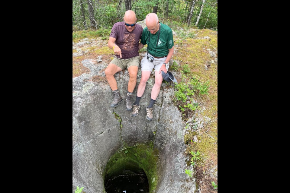
On June 26, he visited the potholes with Back Roads Bill.
“I don't want to give the impression of hubris (excessive pride), but when I see something that I can understand or interpret, I feel a great sense of accomplishment, a real satisfaction that I have the ability to make a story out of a feature.”
He said these natural features are worthy of sharing so people can understand natural processes over time.
The Story
Here is the Nov. 27, 2020 story in its entirety:
Potholes, not the spring kind that affect the alignment of your vehicle but the glacial ones; Village Media readers may know the entire Great Lakes and beyond once drained eastward. That’s a lot of water and there is geological evidence to prove it.
Recently, it seemed to be an anticlimactic Back Roads Bill expression, “Found it! But it’s not the one in the photo?” It would take yet one more day to find the elusive and mother lode of potholes.
Along with erratic boulders and striations, potholes represent present day evidence of mega geologic events like the most recent ice age. Dr. Eric Mattson, a Professor of Geography at Nipissing University in North Bay, says these potholes are the result of massive volumes of glacial melt-water draining through a spillway what is now referred to as the North Bay Outlet.
In terms of process, potholes are formed by stationary rotary currents carrying pebbles and stones (called “grinders”) which abrade depressions in the softer bedrock along the bed of the stream. These grinders ever so gradually wear the holes deeper and deeper into the bedrock. “It is a whirlpool effect of water and gyrating stones of varied sizes. As a result of the constant whirling of the stones, the potholes take on a remarkably symmetrical, round shape.” There is Potholes Provincial Park near Wawa and the Rockwood Potholes near Guelph. Potholes are natural anomalies and are found in many places, access is a matter of available information.
After sixteen years, including many site visits with willing volunteers, searching by bushwhacking an irregular area of 1 km x 400 m, three significant potholes cited in a 1972 report have been re-located. These potholes are within one of the four significant glacial-fluvial spillways that drained all of the Great Lakes and beyond. It was a matter of misinformation; it became a puzzle of interpreting references and more.
In the beginning, it was a Geological Survey of Canada report with a black and white photo, a field researcher is seen, legs dangling over the edge of a deep pothole somewhere west of Mattawa, along what was the main CPR railway line. It was entitled: Quaternary Geology of the North Bay-Mattawa Region by J. E. Harrison.
“The photo shows the larger of two potholes on a granite gneiss ridge in a channel 200 yards east of Morel siding," Harrison’s paper stated. "Deglaciation, permitted waters from the upper Great Lakes to spill eastward through the area.”
We’re talking approximately 8,000 years ago and several outlets drained into the Ottawa drainage system.
“East of where?”
This became the mantra as there was no additional information. Many friends and colleagues and interested people have walked the pipeline to the tracks and searched both sides of the railway corridor, off and on throughout the years; besides it is my avocation.
Two years ago, new spatial information was found. A 2004 academic paper by professor Paul Karrow from the University of Waterloo, included a table of information identifying the Morel potholes but these coordinates were incorrect when using the GPS and the author had not visited the site. The anecdotal field notes were vague and the latitude-longitude was not accurately identified. It is difficult to estimate decimal seconds on a topographic map – as they did not have GPS back in the day.
Local Bonfield resident and Professor Emeritus, Queen’s University, Dr. Larry Dyke became involved.
He is a geologist and undertook a number of searches with me and designed a new search area off of the railway line which represents the bottom of the once fluvial spillway.
Larry says: “It seemed the potholes could be lower. I think there could have already been under-ice flow that could have started the pothole forming. In any event, such a feature indicates a strong flow of water, strong enough to keep cobbles in the pothole swirling, continuing the boring, and for quite some time.“
Again no luck and Larry moved this summer to North Vancouver.
Along came Dr. Jeff Scott from Nipissing University, who wanted to be the “research assistant." He helped meander through the saplings and alders and low-wet areas on a number of trips with his sidekick, dog Juno.
“We tried to train Juno to find potholes but that was more wasted time,“ said Jeff.
A story appeared in a local newspaper but there was no community response as to the location. No one seemed to know.
Facebook responses included sending me photos of other potholes I have highlighted in stories and posts.
It was time to give up. Too many attempts, it was time to move on.
One more review of the literature revealed other researchers who may have been there. What “sealed the deal,” was a new field note reference, within a radio carbon dating paper of 1969 by W.Blake: "90m south of the east end of the CPR shunting track at Morel."
He had actually been there in 1969.
Railway buffs will know a shunting track is a third track, not the siding. It exists but is derelict and overgrown along the one-kilometre corridor, towards the west end, the opposite end of where most of the reconnaissance had been focused.
The afternoon of Friday the 13th was a lucky one. After 16 years of combing both sides of the railway, more than 100 hours of field work and research, and more than a dozen trips to the area, one of the elusive Morel glacial pothole/kettle was located. It wasn’t the largest one depicted in the 1972 photo.
It took Saturday with Jeff to find the larger pothole close enough to the other. Jeff says: "No adventure is complete without an adventure! And in the search for the Morel pothole, this was certainly the case. Attempting to discern what the authors meant with their limited directions became key as did looking through other print material that had been cited by the authors. As information emerged, the adventure certainly took on new twists, new meaning and new opportunities. For me, the third attempt at finding the potholes certainly proved valuable with two circular and deep holes carved in the granite ridge. Good sleuthing, enjoyable time in the outdoors, reiteration of details and perseverance all paid off. Perhaps you will choose to visit the potholes for an adventure of your own."
There are three potholes on top of the low lying ridge of exposed bedrock. The larger pothole is 23 metres away in a northerly direction from the smaller. It measures more than 3.6 metres in depth and is dry.
The smaller one measures 1.37 m across and about the same depth. The interesting aspect here is that it has no fissures or crack for the water to escape. We bailed it out, which took a while for the bucket brigade. There is also an enormous broken pothole between the two which is worth looking at for its cylindrical appearance and depth.
For some reason I could not give up on finding these glacial souvenirs and I will use my fingers and toes to count back the number of times I have searched.
Each time I go back and stare down into the larger pothole, I know why. What on earth could be better than to go back in time? Go and have a look, here’s the map or email [email protected]. Tell me about your favourite pothole, erratic or striation for a treasure hunt.
It is gratifying to see that Village Media readers appreciate the back roads and the stories they tell.


