Day trips to Ontario Parks are a good way to utilize a seasonal pass as there are so many summering things to see and do within a park and its nearby community.
This week we are highlighting three parks further along Highway 11 within the Kapuskasing-Hearst area of Highway 11 North. Kevin Wilson is the Park Superintendent for all three parks. He knows and is passionate about his parks.
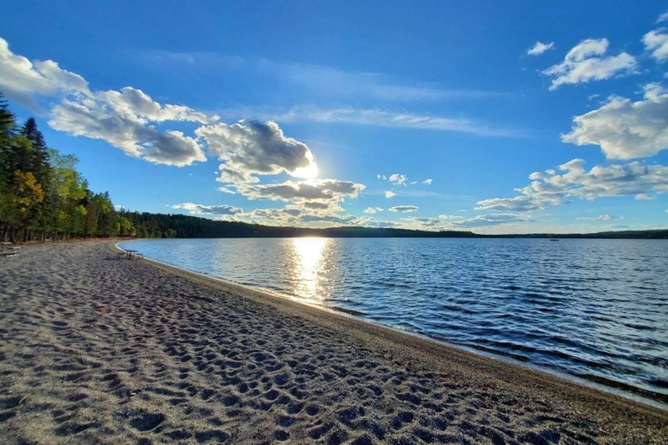
René Brunelle, near Moonbeam
You can’t miss the turnoff to the park it’s a north turn at the alien spaceship in Moonbeam and is located at the tourism information centre. There’s a new chip stand and mini-putt across the street.
This is a gem, you will want to bring along your bicycles for this day trip as the Moonbeam-park bike trails are some of the best in the north. There are seven trails which cover a total of 34 kilometres. The main, direct trail to the park is an asphalted one of 11 km.
Go walking, running, or cycling in the summer as well as snowshoeing and cross-country skiing in the winter. Trails are related to beginner, intermediate and expert. The main trail is fully wheelchair accessible. There are 28 green gates on the map that show loop and sidebar trails.
The Boreal Forest and Claybelt landscape are this park’s defining features. Remi Lake, of which about a third of its shoreline is within the park, is one of the largest lakes in the region.
The lake lies in the Claybelt, a flat forested region with rich clay soils that were once the bottom of a vast lake. Thousands of years ago, this lake contained the meltwaters of glacial ice that once covered all of Ontario.
“The Claybelt is quite different than the surrounding Canadian Shield, in that it is not rocky, and has very few lakes. So, Remi Lake is quite a significant feature in this northern landscape,” Wilson said. “One of René Brunelle Provincial Park’s most interesting stories is told along the La Vigilance Trail. This short, but very scenic trail tells the story of the daring bush pilots who flew flying boats – large pontoon aircraft – from a base called Airplane Island in the 1920s.
“The pilots flew their aircraft across the vast Boreal Forest, looking for signs of smoke. Forest fires were a deadly force, and the Department of Lands and Forests and the Ontario Air Service worked to spot fires and put them out before disaster struck.”
A large forest fire in 1916, known as the Matheson Fire, burned through an area of forest east of Timmins, burning communities and killing around 220 people – one of the worst forest fire death tolls in Canadian history. This spurred the Ontario government to create legislation and a forest fire organization, which included the airbase on Remi Lake where the park is today. The trail is named after one of the fire-spotting flying boats based on the lake – La Vigilance.
“La Vigilance Trail follows the lakeshore, while the Spruce Lowland Trail loops through the park’s Boreal Forest. The two trails combine to provide a great picture of what makes Remi Lake and its surrounding forest special.”
Within the park, Phipps Point should be any visitor’s target for a day trip to the park. As a point of land jutting west into the park, it has shoreline on both sides. And they both happen to be beautiful sandy beaches.
“So if it is too windy on one side you move over to the other,” Wilson said. “It’s also got a great playground for kids, and a beach volleyball court for the sports enthusiast. There are lots of spots for picnicking too. A large picnic shelter can be used for special occasions and large groups”
Fishing in Remi Lake is good. Northern pike and walleye are the main species here, but small-mouth bass are also plentiful. There are motorboat rentals for the anglers in the group, as well as bikes, paddle boards, canoes, kayaks and peddle boats for the self-propelled.
Here’s the park’s site and the Moonbeam Nature Trails site.
Fushimi Lake Provincial Park, near Hearst
The park is 41.2 km or 33 minutes west of Hearst, north on Fushimi Road.
“Fushimi Lake lies completely within the provincial park, and while the lake may look small on the highway map, it feels huge when you’re on it,” said Wilson. “The provincial park has a day use area that’s perfect for families, with a not-crowded sandy beach and canoe, kayak and paddleboard rentals. There are change room facilities for swimmers and lots of space for picnics.
Fushimi Lake Provincial Park has seven sandy beaches in total, so those inclined to paddle or take a motorboat out onto the lake will find many idyllic spots to relax during their trip around the lake.
”Take a rod and reel out with you – the fishing is quite good, with northern pike, walleye, yellow perch and whitefish on offer,” Wilson said.
A fish cleaning station is also available to make things easy at the end of your fishing trip.
Fire Tower Trail is one of two official hiking trails in Fushimi Lake Provincial Park. The trail starts at Fushimi Lake campground and leads to an original 1930s fire tower; it is 4 km in, one way. The trail goes through the forest and along the water with some lovely lake views.
You may be staying in around Hearst and if so, you may want to check out the Achilles Lake Trail. It is a popular short hike for visitors who head to the shores of Achilles Lake to catch the always-awesome sunsets.
The trail meanders through the park’s Boreal Forest and highlights the various species common to this northern forest – balsam fir, black spruce, and Bunchberry with its white flowers in early summer and red berries later in the season. Bunchberry is a creeping form of dogwood, which is most often a shrub.
“The trail ends at the shore of Achilles Lake, which must be the quintessential 'boreal' lake. Spruce trees point to the sky, which seems bigger there than other places, walk the bedrock shore and explore – check for freshwater mussel shells at the water’s edge – otters often leave piles of shells they’ve shucked,” Wilson said.
He sums up with the Fushimi vibe.
“The staff are proud of a vibe many people get when they visit Fushimi Lake Provincial Park.
"It’s a combination of things that will leave you feeling good. It’s those big Boreal skies. It’s that big blue lake. It’s the feeling you get when a big fish pulls on your line.
"The feeling you get when you hear kids splashing in the water and having a great time at the beach, or when you hear the loon call. It’s also the smiles and waves you get from park staff.
"It's the vibe you get when you know you want to visit this provincial park again as soon as you can.”
It is the Town of Hearst’s 100th anniversary officially on Aug. 3. Check out the town's Facebook page and the website for events and while there you will want to stop for a selfie at the tourist information centre with wolves and the moose, the tourism icon is one of the most artistic along Highway 11.
Also, look for the two teepee or beehive burners.
One is at the operating mill (behind the Super 8 hotel) that can be seen safely from the plant’s railway track crossing and there is an older one to the west (Fontaine Drive, west side). These are sawmill wood waste burners, they were free-standing conical steel structures often a visible, community marker; now often not seen; part of the natural cycle of a disappearing heritage.
A sawdust burner is cylindrical. They have an opening at the top that is covered with a steel grill or mesh to keep sparks and glowing embers from escaping. There was usually a lot of smoke being emitted. Like something historic it is neat to see that things have changed.
Nagagamisis, near Hornepayne
The park is located west of Hearst on Highway 11 north and then south on the Hornepayne Highway, # 631. It is about a one-hour drive plus for the 100 km to the entry gate. The Nagagamisis Park has a natural environment park classification in the park system.
The highlight of the day is the Time Trail (closed because of a weather microburst in 2021 and about to reopen) or the hike out to Duck Bay to see the culturally modified trees. Culturally modified trees are living trees that have been visibly altered or modified by Indigenous peoples for usage in their cultural traditions.
Here you will see Eastern white cedar trees, stripped, at one time, by the descendants of the Hornepayne First Nation who lived on the lake (there are two cemeteries at the far east and southeast end of the lake). The inner bark was utilized for a number of domestic purposes including a variety of baskets and ceremonial reasons. Culturally modified trees are recognizable by the scars remaining from the removal of bark, planks or test holes.
The beach at Nagagamisis has fine sandy shores but also has a cobble beach leading you to the tombolo type of point (Duck Bay) that will make rock fans happy. Pebbles from all over the north, dropped by glacial ice, rounded by glacial rivers and Nagagamisis’ waves make for a potpourri of colour, shape and size.
“Nagagamisis Provincial Park is home to many species of migratory songbirds, which you will see and hear. The Boreal Forest is known as Canada’s 'songbird nursery'. Food, especially caterpillars, is abundant and birds can often raise two broods of chicks in the short time they live in the park. Download the Merlin birding app – it can tell you what birds are singing above you as you hike through the forest.”
If you are a fisher, “Fishing on Nagagamisis Lake is a favourite pastime for regular visitors to the provincial park – the lake has some great fishing, with Northern Pike, Walleye and Yellow Perch being the species of choice.” Nagagamisis is a 15 km-long lake, with scenic Boreal shores. Here’s an extra, the boat launch area has a fish cleaning station as well as a fish smoker to smoke your catch before you head home.
If there is time left over journey a little more to the south on Hwy. 631 and visit the geographic centre of Ontario, see this story.
Parks are for people. On a day-visit basis, it is like being on the back roads yours to discover this summer. Here’s the map for the park.


