Updated at 4:50 p.m.
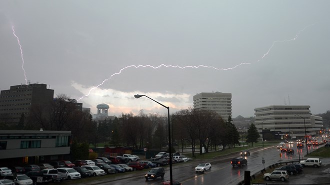
The thunderstorm that had been predicted by Environment Canada has hit Greater Sudbury. Power outages are being reported across the city.
Send us your photos and/or videos of the storm. E-mail them to [email protected].
Updated: April 27, 4:25 p.m.
Environment Canada meteorologists are tracking a severe thunderstorm capable of producing very strong wind gusts and up to toonie size hail.
Severe thunderstorms moving northeast at 60 km/h. Main threats with this storm is strong wind gusts to 90 km/h, large hail and poor to very poor visibility in heavy rain.
Strong wind gusts can toss loose objects, damage weak buildings, break branches off trees and overturn large vehicles. Remember, severe thunderstorms can produce tornadoes. Lightning kills and injures Canadians every year. Remember, when thunder roars, go indoors.
Severe thunderstorm warnings are issued when imminent or occurring thunderstorms are likely to produce or are producing one or more of the following: large hail, damaging winds, torrential rainfall.
The Office of the Fire Marshal and Emergency Management recommends that you take cover immediately if threatening weather approaches.
Please continue to monitor alerts and forecasts issued by Environment Canada. To report severe weather, send an email to [email protected] or tweet reports using #ONStorm.
Original story:
While Greater Sudbury is enjoying distinctly summer-like weather at the moment, Environment Canada is raining on our parade.
The city is under a severe thunderstorm watch today.
Environment Canada reports that conditions are favourable for severe thunderstorms to develop today, capable of producing strong wind gusts. A cold front is expected to sweep through southern Ontario this afternoon bringing showers and a few thunderstorms along with it.
Winds gusts of 90 km/h are possible.
A thunderstorm watch is bad enough, but at least it isn't snow or freezing rain, something other parts of the North are contending with today.
Atikokan, Upsala and Quetico are under a special weather statement warning of heavy snowfall, ice pellets and poor driving conditions. Peawanuck is also under a special weather statement, warning people about blowing snow changing to freezing rain.
Freezing rain warnings have been issues for Attawapiskat, Thunder Bay, Geraldton, Manitouwadge, Hornepayne, Kapuskasing, Hearst, Lake Nipigon, Wabakimi, Superior West, Wawa, White River and Pukaskwa.
Fort Hope, Webequie, Geraldton, Manitouwadge, Hornepayne, Lake Nipigon and Wabakimi are under winter storm warnings.
Snowfall warnings are in place for Lake Nipigon, Wabakimi, Pickle Lake, Wunnummin Lake, Sioux Lookout and Savant Lake.
Meanwhile, severe thunderstorm watches are in place for Chapleau, Gogama, Kirkland Lake, New Liskeard, Temagami, North Bay and West Nipissing.
To report severe weather, send an email to [email protected] or tweet reports using #ONStorm.