It could be attributed to early indigenous peoples, the Vikings, geologic time or the aliens. What is the origin of these massive stones?
There are many mysteries off of the back roads. There are mystery stone configurations around the world like Stonhenge, Britain’s greatest prehistoric monument. Stonehenge remains a mystery as scientists ask: was it a health spa, or a cemetery?
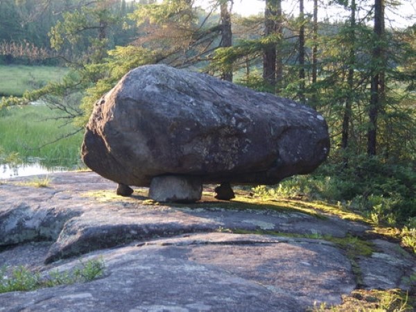
Dolmen Mystery Stones
There are dolmen stones in Northern Ontario. A dolmen usually consists of three or more upright stones supporting a larger stone. It remains unclear when, why, and by whom the earliest dolmens were made.
The oldest known dolmens are in Western Europe, where they were set in place around 7,000 years ago. Archaeologists still do not know who erected these dolmens, which makes it difficult to know why they did it.
They are generally all regarded as tombs or burial chambers, despite the absence of clear evidence for this.
In North America many people have attached different theories and legends to the dolmen – some of them are: these are burial markers, it’s a Viking marker; a way to communicate as routeway markers or it is a glacier erratic.
Dennis Smyk a recipient of the Queen’s Jubilee Medal, was the editor of the Driftwood newspaper in Ignace and a licensed avocational archaeologist, passed away in 2018. He has identified and registered hundreds of archaeological sites throughout northwestern Ontario.
“I can’t ‘write up’ the one (dolmen) we visited (see map) because they are not recognized as archaeological sites (unless one finds other stuff [Native artifacts or pictographs] on the sites)," he wrote. "I have a difficult time accepting that the glaciers deposited so many large stones on top of two or more smaller ones.”
Some prescribe to the erratic theory.
A glacial erratic is a piece of rock that differs from the size and type of rock native to the area in which it rests these are found just about everywhere in northern Ontario.
"Erratics" take their name from the Latin word errare, and are carried by glacial ice, often over distances of hundreds of kilometres. Erratics can range in size from pebbles to large boulders. Since they are transported by glaciers, they are one of a series of indicators that mark the path of prehistoric glacier movement.
Micah Hanks is a writer, podcaster, and researcher whose interests cover a variety of subjects his website is www.mysteriousuniverse.org.
“Of course, while glacial movement appeared to be a reliable mechanism for the movement of such massive stones, the question remained as to what might have placed them on top of glaciers, to begin with," Hanks said. "The leading theory about this among nineteenth-century scholars had been that landslides and rockfalls, occasionally helped along by the movement of the encroaching ice itself, had likely resulted in stones coming to rest upon the ice sheets, which were thereafter carried along as the glaciers moved."
"Once the ice sheets began to melt and the glaciers receded again, these stones—some of them carried along for great distances—would have found their way to their present positions on the ground far from where they originated,” Hanks concluded.
When you visit a number of dolmen sites your mind starts to behave like the proverbial pendulum. Is it by happenstance the melting ice occurred in such a way the larger boulder became supported by the smaller?
White River
The White River dolmen took more than five years to find and to finally get there. The location is one of those 'don’t tell mom' jaunts.
After finding the first referenced dolmens, Boundary Waters, Minnesota and Ignace, there was an obscure story found on the Internet entitled Outdoorsmen Revisit Mysterious Rock Formation. It involved two wilderness-type of canoeists, John Evashevski and Michael Lehto of St. Ignace, Michigan who first saw the stone 50 years ago.
"They were either made to be markers or they may have a religious or astrological significance," said Lehto. "They are fascinating because it shows the people of the late stone age were moving through North and South America, Europe and Scandinavia."
His story was published in the archaeology magazine Ancient American in 2005.
Research - maps and access, and then plotting a course came next; two failed attempts transpired because of time, weather and access.
I commandeered two forestry professionals working in the White River area. They were eager and open-minded (also younger), important character traits when searching or “bushwhacking.”
Off we went on a very grey, wet day. The roads had changed because of logging. The meandering nature of the oxbow, Pokei Creek caused dead ends. And then there were the beaver drags - the in/out and drag the canoe over routine, as you straddle the trapeze nature of the transitional dam.
But then, there it was on the south side of the tiny island at the rapids just as John and Michael described!
The sun came out as expected. The formation of rocks was unmistakable. The supporting rocks were different and had to be placed and there were extra rocks covered with lichens on top as if placed like a bricklayer reaching for the stone.
One of the two in the party was Jesse Gaudette, a band member of nearby Pic Mobert First Nation.
“Being a First Nation member I have always felt a connection to the land, especially in the White River and Pic Mobert areas. I am an active land user, whether it is for recreation or sustenance," said Gaudette. "When we first approached the stone I was in awe and couldn't believe that there was a dolmen in my backyard."
"Being in the presence of the rock was spiritual. Instantly I felt a rush and acted upon it by praying and placing tobacco down at the site," he said. "Since we visited the rock, I haven't stopped thinking about it. I'm always curious about when my next trip back will be, and who will be with me next time!”
The other 'trooper,' Svetlana Zeran said, “It was quite spectacular to leave in the rain and just as we pulled up the rain lifted, leaving rising morning mist off the dolmens stones which were illuminated by the first sun of the day."
"It felt like we were going back in time almost, witnessing something mystical and older. Much older than recorded history. Leaving me with a feeling that there are still mysteries to be found and wondering about the people who put these structures together," she said. "It was quite surreal. I am in the process of reporting this site to the MNRF so that it can continue to remain alive and be protected.”
It will be easier now. White River, west of Wawa is also a day trip. At the north end of town, just past the mill, turn west or left off of Highway 17. Cross the railway tracks and the White River bridge on the Domtar 600 Rd. , heading southwards. At 8.9 km there is a junction, turn south, then drive another 20.3 km from the junction.
These are good logging roads. Access is on Soulier Lake, paddle to NE corner, through the wetland to the meandering Pokei River (Topo 42 C6 – Pokei Lake).
The dolmen stone is another 2 km, on the south side of the small river island. 16 U 625113 5360902 or N 48° 23 21.3” W85° 18’ 38.3”
Wolf Lake
David Bain is a former history teacher from Kitchener. He was making his way through the popular Chiniguchi-Matagamasi canoe route. He contacted me after reading the www.steerto.com Northern Ontario-Facebook post on the White River dolmen.
"We were just out to hike the cliff near our campsite to see what was up there. I used to teach history, and am an avid reader of books on history and pre-history, including author Barry Fell's books on pre-Columbian European contact...so yes, I laughed right away and made a joke about the Wolf Lake dolmen."
And it was soon to be shared and discovered; after trading some emails about location.
Off we went to Wolf Lake known to have the largest stands of old-growth red pine in the world.
The author was with an outdoors friend, Ken Waller who helped find the dolmen referenced by David Bain.
"It has been suggested the Sudbury basin meteorite impact was linked to the aliens. This could have been an Inukshuk-like marker for them,” Waller said.
He also said because of the cave-like structure it is more likely a vision quest site for early indigenous peoples. A cursory examination revealed some charcoal. After being posted on Facebook a Wendigo event was also entered into the mix of explanations.
Directions then. East of Sudbury, find the Kugagami Rd., turn north of Highway 17 West. Drive northwards approximately 11 km and cross what was the railway line. Continue to follow the signs to Sportsman’s Lodge for another 11 km.
You will come to a major intersection and turn left or northwards (do not follow the signs to the Sportsman’s Lodge and Kukagami Lake.) Turn on to Matamagasi Lk. Rd. and then Bushy Bay Rd.
You will be travelling approximately 10 km to Lake Wanapitei/Matamagasi Lk. Narrows. (This is where you could launch a canoe.) Or drive on past the narrows between Lake Wanapitei and Matamagasi.
You will drive past many entrances to camps and cottages. It remains a good gravel road. This is where your GPS and map come in handy. You can launch a canoe on Silvester Lake or the far north end of Wolf Lake at the bridge to Dewdney Lake. The dolmen is on the top of a small cliff just NE of the campsite on the northeast shore of Wolf Lake. WGS 84 Zone 17 T E 0528346 N 5189670 and N46° 51.600’ W 080° 37.689’.
The truth about the dolmen stones rests with what you want to see, hear, and know. Maybe we never want to know? Maybe only the aliens know.
The pursuit of finding other stones continues, along with the mystery. There is a new one just located and there are more to discover.
Please contact me if you know of any and see the map for the various Dolmen sites written about in this column.