Sudbury street names are not just something on a map or your GPS, they provide hints about local history.
In late 1886, a CPR official in Montreal drafted a site plan and assigned street names for the wilderness settlement. Sudbury had been considered a depot and temporary construction site three years earlier.
The discovery of nickel in the area ensured its future.
Streets running east to west in the central area would be named for trees such as Elm, Larch, Cedar, Spruce, Beech, Pine, Oak and Walnut. Streets running north to south would be named for Canadian governors-general such as Durham, Lisgar and Lorne and later, Grey, Minto and Stanley.
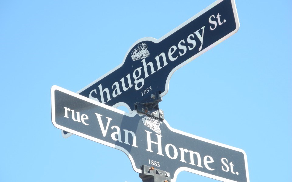
Streets Van Horne, Shaughnessy, Drinkwater were named for prominent CPR executives.
Sir William Cornelius Van Horne was responsible for the construction of major portions of the railway including the Callander to Thunder Bay line. He was named president of the rail company in 1888. Thomas Shaughnessy was general manager of the company and succeeded Van Horne as president in 1899. Charles Drinkwater was the company's first secretary-treasurer.
The road along the railway tracks was originally named Station Road, but in 1940, it became part of Elgin, which was named after Lord Elgin, governor of British North America from 1847 to 1854.
Worthington Crescent was named after CPR construction superintendent James Worthington, who named the rail depot "Sudbury" after his wife’s birthplace in England.
As the CPR pushed into northeastern Ontario, Jesuit priests began to establish missions. Father Jean-Baptiste Nolin laid the foundations for the Sainte-Anne-des-Pins mission in 1883 at Sudbury.
Part of Queen Street in the Flour Mill was renamed ‘Nolin’ in his honour in 1983. That same year, another part of Queen was renamed Bruyère. Mother Elisabeth Bruyère was the founder of the Sisters of Charity in Ottawa.
Ste. Anne's rectory on Beech Street is the oldest brick building in Sudbury. After a period of urban renewal, some original streets disappeared to make way for Ste. Anne's Road in 1979. The name recognizes the early Francophone settlement.
Sudbury's infamous Borgia Street, a colourful working-class downtown neighbourhood, was once considered one of the toughest in Canada. It was demolished to make room for Elm Place mall (formerly the Rainbow Centre and formerly the City Centre). The neighbourhood was home to a sizable population of Francophones and European immigrants, and remains very much part of the city's folklore.
The street was named for St. Francis Borgia, a Spanish nobleman who became a Jesuit priest.
Frédéric Romanet du Caillaud, the man who gave the city the Grotto of Our Lady of Lourdes, once owned a large tract of land that extended along the north shore of Ramsey Lake, including all of what is now considered the Minnow Lake area. Tarneaud Street was named for his mother, Amélie Tarneaud.
Romanet du Caillaud Street was renamed Howey Crescent (1933) and later Howey Drive (1961) because the name was considered by some local politicians hard to pronounce.
Howey Drive was named after Sudbury's first pioneer settlers, Dr William and Florence Howey.
It is believed Brady Street was named after Benjamin Brady in 1905 after the owner of the Sudbury Temperance Hotel, which was located on Station Road.
Adie, Baker, MacKenzie and Davidson streets were named in 1909 for teachers at Sudbury High School.
The Holditch family were property owners and builders. As such, they named Ernest, Gilman, Ethelbert, Reginald, Dean, Logan and Damaris streets in the West End and Gatchell for family members.
The Kingsway was named in 1939 to honour the visit of the King George VI and Queen Elizabeth to Sudbury.
Barry Downe Road was named after the Barry and Downe families. (The street signs say Barry Downe, but it is commonly spelled Barrydowne.)
The Downes sold 20 acres of their property to Principal Investments Limited in the 1950s. The land was developed into a shopping plaza that would become the New Sudbury Centre.
William Barry was reeve of McKim Township. He subdivided much of the land in the Minnow Lake area. His wife, Maurerite, operated a general store and post office. She named many of the streets after her seven offspring and more than 30 foster children.
Much of the information for this article came from a fascinating book,
Sources
- "Street Names of Downtown Sudbury", written by Lionel Bonin and Gwenda Hallsworth and published by Your Scrivener Press in 1997.
- “Sudbury Rail Town to Regional Capital” (Dundurn Press, 1993), edited by C.M. Wallace and Ashley Thomson
Vicki Gilhula is a freelance writer. She is a former editor of Northern Life and Sudbury Living magazine, and has a special interest in local history. Then and Now is made possible by our Community Leaders Program.