The federal government's recent warning that 2023 could be the worst Canadian forest fire season on record seems to be supported by the continually increasing numbers of wildfires burning in Northeastern Ontario. With one new fire reported Monday, there are now 31 actives fires burning across the region.
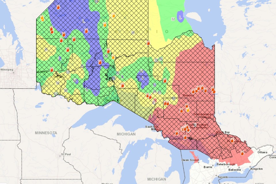
The fire hazard remains high to extreme across the Northeast. For a closer look at fire hazard conditions in your area, view our interactive map.
The impact of all these fires is evident in the hazy skies we've been seeing, the lingering smell of wood smoke and daily warnings about poorer-than-normal air quality. And with nothing beyond a chance of showers occasionally in the forecast this week, the dry conditions are likely to continue.
The newest fire, confirmed on June 5, is Timmins 8, which is 0.8 hectares in size and not yet under control. The fire is located 2 km west of the Akonesi Chain of Lakes Complex and 0.8 km south of Brady Lake.
Including new fires, there are currently 31 active fires in the Northeast Region:
- Fires currently under control include:
- Sudbury 20 at 0.5 hectares
- Sudbury 13 at 0.1 hectares
- Cochrane 2 at 0.4 hectares
- Wawa 2 at 105 hectares.
- Fires being held include:
- Chapleau 7 at 1 hectare
- Algonquin Park at 6 hectares.
- Fires currently not yet under control include:
- Timmins 8 at 2 hectares
- Timmins 7 at 120 hectares
- Pembrooke 1 at 50 hectares
- Cochrane 9 at 5 hectares
- Cochrane 8 at 35 hectares
- Cochrane 7 at 1,840 hectares
- Cochrane 6 at 1,239 hectares
- Cochrane 5 at 5 hectares
- Cochrane 3 at 80 hectares
- Sault Ste Marie 3 at 2.8 hectares
- Hearst 4 at 12 hectares
- Algonquin Park 7 at 2.1 hectares
- Sudbury 19 at 0.1 hectares
- Sudbury 18 at 1.5 hectares
- Sudbury 17 at 335 hectares
- Sudbury 16 at 15.8 hectares
- Sudbury 15 at 3.4 hectares
- Sudbury 14 at 0.5 hectares
- Sudbury 11 at 31 hectares
- Sudbury 10 at 76 hectares
- Chapleau 6 at 209 hectares
- Chapleau 3 at 500 hectares
- Wawa 3 at 6,810 hectares.
- Fires being observed include Cochrane 1 at 45 hectares.
Travel remains restricted in several area across the Northeast. Travel is restricted in the Chapleau-Wawa District due to the Wawa 3 fire, which has resulted in prohibited travel along about 10 roads in the district until further notice. The restricted roads include:
- 400 south of where Road 400 intersects the White River Forest Unit boundary
- Road 300 south of the intersection of Road 300 and Road 350
- Road 500 west of the intersection of Road 500 and Road 550
- Road 226 west of the intersection of Road 226 and Hwy 631
- “Mink Lake East" Road north of intersection of "Mink Lake East" Road and Hwy 631
- "Mink Lake Boat Launch" Road north of intersection of "Mink Lake Boat Launch" Road and Hwy 631
- Operational Road 631-02 north of intersection of Road 631-02 and Hwy 631
- Operational Road 631-01 (aka. Tower Road) north of intersection of Road 631-01 and Hwy 631
- Road 100 north of intersection of Road 100 and the Picnic Lake Road
- North Reagan Road north of intersection of North Reagan Road and Road 50
Travel restrictions are also in place in the Hearst-Cochrane-Kapuskasing District due to several fires in that area, including two larger ones: Cochrane 7 at 1,840 hectares and Cochrane 6 at 1,239 hectares. An Emergency Area Order was imposed there this morning (June 6), prohibiting travel without a Travel Permit on the following roads:
- Translimit Road eastwards beginning where it intersects with the Northwest Industrial Road at UTM Zone 17 E 529709 N 5434121
- Translimit Road west of the Ontario-Quebec border at UTM Zone 17 E 608042 N 5423187
- Northwest Industrial Road north of the Abitibi bridge at UTM Zone 17 E 523719 N 5402519
- Reaume Esker Road beginning where it intersects with Town Dump Road at UTM Zone 17 E 488675 N 5428518
- Potter Road West of the TC Energy Plant at UTM Zone 17 E 507658 N 5413024
- Connaught-Evelyn Road North of the Pallet Lake access point at UTM Zone 17 E 491692 N 5410633
The fire hazard remains high to extreme across the Northeast Region.
Due to the extreme forest fire hazard, the Ministry of Natural Resources and Forestry declared a Restricted Fire Zone as of June 1 for the districts of:
- Hearst/Cochrane/Kapuskasing
- Chapleau/Wawa
- Timmins/Kirkland Lake
- Sault Ste Marie/Blind River
- Sudbury
- North Bay
- Minden/Parry Sound/Bracebridge
- Pembroke
- Northern portion of the Peterborough/Bancroft District
- Southeastern portion of the Far North District.
No open air burning, including campfires, is permitted within the boundaries of a Restricted Fire Zone. Portable gas or propane stoves may be used for cooking and warmth BUT must be handled with extreme caution.
All burning permits are suspended. The Restricted Fire Zone is in place until further notice.