According to the dictionary, a hole in the wall is often a small and often unpretentious out-of-the-way kind of place.
Time to start exploring again, there are three interesting holes, easily found, in rock walls on your way through Wawa. Don’t go by, stop!
So yes, for good reason the first stop. We know this Lake Superior community as the land of the big goose. You can see it here on the webcam, any day, the snow is waning and geese are now migrating but this one is not flying away. As of this story’s submission, there is some snow remaining. This pterodactyl-sized Canada goose icon is the largest of its kind in Canada and one of the most photographed landmarks in North America. After the selfie, it is on to find these very different holes on the back roads.
The big hole #1
Wawa’s contemporary history centres around iron ore mining. From its beginning in 1898 until its final year in 1998, Wawa held a unique position in Canadian mining history. It was once the richest iron ore deposit in the country and significantly contributed to the insatiable appetite of the steel industry.
The 1950s were the golden years, Wawa and her increasing population were carving a permanent town site on the banks of Wawa Lake, the new Helen Mine and the sintering plant were establishing their roles both as competitive participants and as technical leaders in the iron ore industry. The sintering plant (1937) smelted the iron into sinter which could be easily transported to the steel mill in Sault Ste. Marie. By 1966 the sinter plant was producing over 1.8 million tons yearly reaching its maximum capacity.
Years of prevailing SW winds have created a plume of defoliation NE of town; check out the Google Earth image, and zoom out a bit, it is so discernible this blight on the landscape. Called the Wawa badlands, it is a great area for blueberry pickers and that is about it;(this area though has long been touted as the next kimberlite-diamond discovery.)
Johanna Rowe has written several local heritage books, and I am looking forward to the next, on the Group of Seven artist, A.Y. Jackson who summered on the shores of Lake Superior. An earlier one highlighting the iron ore history is entitled, ‘Heart of a Mountain –Soul of a Town.’ She said, “As Wawa, in this 21st century, we look back on 100 proud years of iron mining heritage. We must take lessons we have learned from the successes and failures of a struggling single industry town, and put them towards the evolution of a unique community that has come to understand the benefits of our rich natural and cultural resources.” But you cannot see the remains of the Helen Mine operation it is beyond the protective fence of the present owner Essar Steel Algoma.
But you can see the biggest hole – the Sir James Mine, a massive pit that allows a view that helps with understanding industrial technology and scale. It is worth the view. Her book tells the tale of what was; another northern Ontario resource-based story.
Travel towards Chapleau, on Highway 101 East. Turn on the road at the end of Wawa Lake; 8 km from town. The road skirts the pit on the west side; 1.75 km from Highway 101; park at the curve you see the berm; walk NW and explore. The bottom of the pit is now a lake. Johanna believes it is now about ten metres deep or more. If you travel further to the NW you can easily see another northern Ontario iron ore pit in Atikokan a legacy environmental catastrophe, but not the Temagami and Kirkland Lake iron ore pits these are other big holes from the past that are now closed to the public.
Bat cave – hole #2
The little brown bat in Ontario is “endangered.” Bats are the only mammals that can fly; their wings are folds of skin stretched between elongated finger bones, the sides of the body, the hind limbs and the tail.
Why the massive die-off? White-nose syndrome (WNS) is an emergent disease of hibernating bats that has spread through eastern North America at an alarming rate (80% mortality). The fungus grows in humid cold environments, such as the caves and mines where little brown bats hibernate. WNS affects bats by disrupting their hibernation cycle so that they use up body fat supplies before the spring when they can once again find food sources.
Since the winter of 2007-2008, millions of insect-eating bats in 25 states and five Canadian provinces have died from this devastating disease. WNS is named for the white fungus, Pseudogymnoascus destructans, that infects the skin of the muzzle, ears, and wings of hibernating bats. WNS continues to spread. Humans, (one reason) are suspected of spreading the disease through contaminated clothing (cave to cave, abandoned mine to another, while exploring).
It seems bat management guidelines have not been fully updated since 1984, see page 18 about mines and caves. But the bats are making a comeback as in this back roads story of October 2020. There is a 2020 government response statement entitled ‘Protecting and Recovering Little Brown Myotis, Northern Myotis’ and Tri-colored Bat to protect and recover all of Ontario’s species at risk, see page 10 about mining applications. There is also an Ontario government primer on bats you might encounter and how to report sightings. You will be looking for them on the up-and-coming hot evenings of summer.
There was a program in development to grate abandoned mining adits and air vents. This allowed bats to come and go, in and out, but restricted you to entering adits. There are just too many abandoned mines as referenced in this October 2023 story on the Renabie Gold Mine.
The depicted bat grate is located on Highway 101 NE towards Chapleau. It is located on a small rock face, 3.6 km from town, on the east side of the road; there is a small pull-off on the same side (it is 4.7 km from the turnoff, back to town from the Sir James Dunn pit turnoff located at the end of Wawa Lake); (WGS 84 N48° 00.196’ W84° 43.587’ or 16 U 669582 5319164). An interesting measure in protecting habitat from a hole created by past mining.
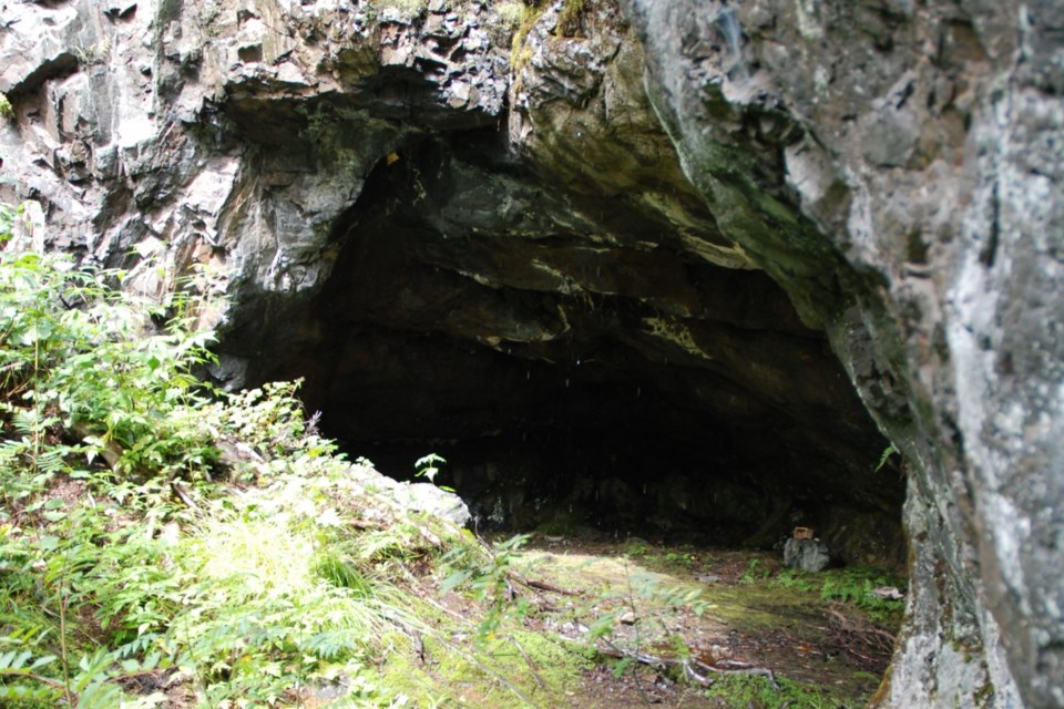
Medicine cave – hole # 3
Where you will stand think of the forces of the former inland sea, greater even than what we know as the Great Lakes, formed this sea cave, waves seething at the rock face of an ancient coastline. This sea cave is as long as the water can reach. The size of the sea cave you will visit is dependent on the kind of rock; this rock is granite, very hard.
Sea caves are formed by the power of the ocean to attack zones of weakness in coastal sea cliffs. The weak zone is usually a fault, or fractured zone formed during slippage. Another type of weak zone is formed where dissimilar types of rocks are inter-bedded and one is weaker than the other. Typically there is a dike or intrusive vein of more easily eroded rock found within a stronger host rock.
This is most likely the cause of the formation of the Medicine Cave. Intrusions are typical of the rock formations in Northern Ontario. The cave may have had a very narrow crack into which the waves of millions of years ago penetrated and exerted a tremendous force, cracking the rock from within. Sand and rock carried by waves produce additional erosive power on the cave's walls. This sediment is now covered by organic material and you have walked on this as you approach the opening of this sea cave.
When you visit the cave also think about the Medicine Wheel. The Medicine Wheel is one of the most important teachings of the Anishinaabe (Ojibway), and includes other teachings, such as the four directions (north, east, south, west), the four colours of the races of man (red, black, white and yellow), and the four stages of life (spiritual, mental, physical and emotional).
A vision quest is simply a search for the meaning and purpose of life, related to the Medicine Wheel. It's one of the reasons any religion exists. Throughout the millennia humankind has hoped that life is more than just survival and eventually death. There has always been the need to search for some sort of significant spirituality that guides us beyond just our physical existence. In the days of the Native Medicine Man, particularly youth, seeking guidance, would travel to remote destinations. These vision quest sites would often be promontories, cliffs or caves. These physical sites were created through the movement of land and water through geomorphologic time.
You will drive south of Wawa on Highway 17 and find the road heading west to Michipicoten Harbour. Drive about 1 km and you will come to an intersection. Turn right, drive over the small wooden bridge and then you will take a sweeping left, leaving the houses behind. You will come to Silver Falls, there are three falls here to see, one above and one below the one you see! Drive on past the cemeteries, there is a sweeping curve to the right and you will come to a left-hand turn leading to Superior Adventures… which is heading west. Start to slow down, you will pass a small rock-cut and see some utility poles paralleling the road. Look carefully to the north or right for the small trail entrance, it is hard to spot. The walk-in is about 250 m. If you come to the next driveway/road on the right/north you have gone too far; (N47° 56’ 18.2” W84° 50’ 26.9” or WGS 84 Zone 16 T 661254 5311708).
It is a spiritual place identified by the nearby Michipicoten First Nation (MFN). See ‘Awechigewin’ - A Land Use Plan for Michipicoten First Nation, 2022, see page 58. “The Medicine Cave is a historic Sacred Site used for gatherings and ceremonies, brought back to MFN recently in a deal with Brookfield Energy. There has been renewed interest and increased use of this site since its transfer back to Michipcoten for ceremonies and community use. Based on feedback from the Land Use Plan Survey, citizens would like to see improved access and signage, but also want to be careful that the sacredness of the site is retained and respected.” Through this opportunity and understanding, you will show reverence.
Here's the map for the “holes.” The bat cave is close to the iron ore pit.
So make sure you exit and take a gander at the famous goose and then move on to the out-of-the-way holes on the back roads.


