Anyone who visits the Ontario Power Generation dam and generating station at Abitibi Canyon will likely be awestruck by the amazing geography there as well as by the massive dam structure itself.
It is an amazing piece of industrial architecture located smack in the middle of Northern Ontario's beautiful wilderness.
I have visited there twice. One time was to launch an epic canoe trip north on the Abitibi River, and eventually to Moosonee. It took 12 fabulous days.
My first visit to the canyon was for a terribly sad news story. It was to cover a plane crash where all 10 souls aboard an Austin Airways airplane would lose their lives when the plane hit high-tension power lines very close to the dam.
I was a young reporter living in Timmins when I got a phone call on a Sunday morning, advising that a plane inbound for Timmins had crashed at the Abitibi Canyon, north of Smooth Rock Falls the day before.
I almost didn't believe the call. The story had not yet made the news. That would be my job. It took me some time to find the crash.
I was the only reporter there. No one else was around. It was almost a full day after the crash. The wreckage was still smouldering on a remote hillside north of the dam. An Ontario Provincial Police officer showed up within an hour, and was surprised that anyone else had found the site. He let me stay to shoot photographs.
Construction of the dam began in 1930 and gave work to more than 2,000 labourers. It was opened in 1933 and provided much needed energy to a host of Northern Ontario paper mills and mining operations.
The project was started by Ontario Power Service Corporation, a subsidiary of the Abitibi Power and Paper Company. Eventually it was sold to Ontario Hydro.
Back then people were needed on site to run the operation. That was the reason that a "colony" of homes, a school, a church, a community centre, a dining hall and staff house was created there. It was where Ontario Hydro was producing nearly 400 megawatts of clean, reliable energy.
Ironically, several years later, Ontario created the Royal Commission on Electric Power Planning, also known as the Porter Commission. The commission was mandated to look into Ontario's long-range planning for Ontario Hydro.
It was late summer in 1976 when several members of the commission were on a flying tour of Northern Ontario communities to learn more about the needs and demands for Ontario Hydro in the far North.
It was Saturday, Sept. 4, 1976 — the Labour Day weekend — and several members of the commission were planning to head back to Southern Ontario. They were departing from Moosonee and headed for Timmins, where they could catch a connecting flight to Toronto.
It was all revealed at an inquest that was held a couple of months later in Kapuskasing.
It was during the lunch hour that Saturday when the pilot Doug Clifford was preparing the plane, a deHavilland Canada DHC3 Otter, registered as CF MIT. He called the company radio operator at the Austin Airways office in Moosonee, requesting weather information.
The first information provided to the pilot indicated acceptable weather conditions for a VFR flight (visual flight rules) meaning the pilot could fly the plane using visual ground references.
Otter CF MIT departed Moosonee at about 12:30 p.m. that day, the inquest was told. Several minutes later, pilot Clifford advised the radio operator he estimated he would be landing at the South Porcupine (Timmins) float plane base at about 2:30 that afternoon. He had nine passengers on board. Some minutes after that, the radio operator tried to contact Clifford to advise that the weather in Timmins and the weather enroute was getting worse. For some reason, that radio message did not get through. There was fog. The cloud ceiling was dropping to roughly 1,000 feet.
The elevation at Moosonee Airport is about 30 feet above sea level. And for float planes, the elevation of the nearby Moose River is virtually at sea level. The inquest was told that some of the terrain around the Abitibi Canyon region is about 950 feet above sea level. It is possible the plane had followed the Abitibi River for ground reference as it flew south toward Timmins, the inquest was told.
In effect, as the plane continued flying south, the ground rose up to meet it. The inquest was told that at 13:37 that day, the plane collided with at least two of the heavy high-voltage lines leading away from the hydro dam.
At the inquest it was suggested that Clifford had flown high enough to clear the height of the dam, but may have seen the power lines only at the last moment and tried to swerve away before the floats on the plane came into contact with them.
The plane fell to the ground on the hillside north of the dam. The plane also burst into flames. The pilot and the nine passengers all died.
The wreckage was not found for roughly five hours. Some people canoeing on the river saw the fire on the hillside.
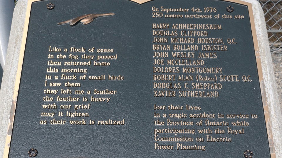
There is a bronze plaque situated at the dam in honour of those who perished.
The names of the victims are etched on the plaque along with a tribute to those who "lost their lives in a tragic accident in service to the Province of Ontario."
Len Gillis is a Local Journalism Initiative reporter at Sudbury.com. He covers health care in Northern Ontario.