City council has given city staff the green light to move forward with a $3.7 million plan to deal with flooding in the Flour Mill area.
Councillors agreed to set aside $350,000 from the 2012 budget for engineering services so work can start later this year to fix the issue.
Ron Norton, drainage engineer with the City of Greater Sudbury, presented the report to city council on Feb. 9.
“We have investigated...different alternatives for drainage improvements,” he said. “These include alternatives dealing with larger pipes, drainage channels, diversions and flood storage.”
While several options were mentioned, Norton only went into the details of four. He said each option could be phased in over time. If the flooding situation is truly going to be resolved, all four would need to be implemented, he said.
The first option would be the creation of a new regional storm channel to the low area of Mountain and Leslie streets and would cost $1.8 million.
The second option would lead to the creation of a northeast diversion channel and would cost $700,000.
The third option would result in the construction of a new flood wall adjacent to the storm water pond in the Sunrise Ridge subdivision and cost $200,000.
The final option, with a price tag of $1 million, would create a division in the outlet of the storm water pond.
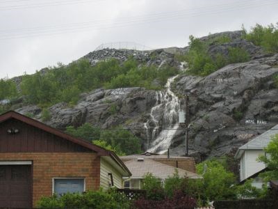
“Flooding in the low area of Mountain and Leslie Streets will be alleviated,” he said. “The waterfall issue (on area properties) would be resolved.”
Ward 12 Coun. Joscelyne Landry-Altmann, representative for Flour Mill, said although flooding has always been a concern in that area, it has become worse since the development of a Sunrise Ridge subdivision.
Photos and videos taken by Mountain Street residents during rainstorms, which displayed flooding and waterfalls pouring into the backyards on the street, were shared by Landry-Altmann during the presentation. A photo dated January 2011 showed an ice cap on the rock behind a home on Mountain Street. No ice was visible in a 2006 photo, taken before the Sunrise Ridge development was built.
“The residents are edgy when they see dark clouds approaching,” she said. “They dash home at lunch to see if their basement is flooded. Our aged infrastructure is failing.”
City council unanimously agreed to accept put aside the $350,000 in the 2012 budget to use on fixing the issue.
A public input meeting is scheduled for Feb. 24 at Tom Davies Square to give residents more information, and a full report on the project will be presented. A time will be announced at a later date.
Join Sudbury.com+
- Messages
- Post a Listing
- Your Listings
- Your Profile
- Your Subscriptions
- Your Likes
- Your Business
- Support Local News
- Payment History
Sudbury.com+ members
Already a +member?
Not a +member?
Sign up for a Sudbury.com+ account for instant access to upcoming contests, local offers, auctions and so much more.