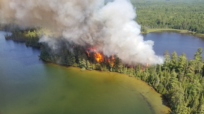
Three new forest fires were confirmed in the Sudbury sector Wednesday, says a release from the Ministry of Natural Resources and Forestry.
They are all 'being held,' which means they are under control, but still smouldering. Lightning strikes are the suspected cause. Sudbury 44 covers one hectare and is located about 12 km northwest of St. Charles. Sudbury 45 measures 0.1 of a hectare and is located south of Redpine Lake, northeast of Capreol. Sudbury 46 measures 0.1 of a hectare and is approximately five km northeast of Markstay.
By late afternoon Wednesday, there were 43 active forest fires across the Northeast, 19 of which are not yet under control, while 24 are either being held, under control or being observed.
“Recent periods of heavy lightning observed over the Canada Day long weekend have sparked several new fires in the Sudbury and North Bay regions,” the release said. “There were nine new starts today, at the time of this update.”
Three new lightning-caused fires were discovered in the North Bay sector and were under control as of late Wednesday afternoon.
North Bay 29 is located approximately seven km northwest Thorne and covers 0.3 of a hectare. North Bay 30 covers 0.1 of a hectare. It is located about 1.5 km east of Mann Lake, just west of Tonomo Lake Road. North Bay 31 located one km south of Sargesson Lake in Nipissing District. It covers 2.5 hectares.
A fire in Parry Sound is being held at 0.2 of a hectare and is located south of the Noganosh Lake Provincial Park boundary. Timmins 8 is not yet under control at two hectares. It is located approximately 12 km southeast of Hwy 560
“The forest fire hazard has been predominantly high to extreme in the central and southern portions of the Northeast Region today,” the release said. “Areas north of Wawa and the Hwy 11 corridor are showing a moderate to low hazard.”
The scorching summer so far has led to a surge in the number of fires in Ontario. Last year, there were 121 in total; so far this year, there have been 426. The 10-year average for annual forest fires is 340.